| OFFLINE
MAPS |
 |
With Maps 3D you
can save any parts of the famous
OSM map including many hike and
bike trails on your phone for
free. No need for data connection
- all the map and terrain data in
your pocket.
openstreetmap.org
|
| |
|
- Easy Map
handling with Mapmanager
- See the size and name of every
map
- Load the desired area either
around a track or choose the area
on a online worldmap.
|
|
 |
| TRACKS |
 |
Use any tool to
create the track you want to use
or choose from the rich variety
already saved maps in the
Everytrail.com portal. Once
imported or tagged as favorites,
you can import them immediately
into the app.
|
| |
|
- Track import
via Everytrail.com
- Track export simply by email
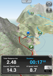
- A second route can be shown next
to the currently recorded one
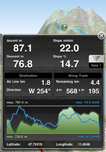
- Realtime profile showing your
speed and height above ground
- See your average and current
speed as well as the distance and
the height above ground at any
time
- Adjust the GPS recording
tolerance for position and time
|
|
 |
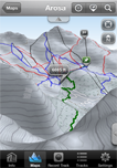
| MAP
DISPLAY |
 |
Knowing more
about the terrain surrounding you,
can be of great help either in
risky conditions or simply to get
a better estimations of slope and
length of the planned trip.
|
| |
|
- Real 3D Views
from any perspective
- Shaded 2D Map for better
orientation
- Zoom and rotate the map view
with the iPhone gestures
- High resolution terrain model
- Choose from north-up or your
direction of travel or rotate the
map by yourself
- Moving the map away from your
position shows the precise
distance and height difference
- Adjust the elevation factor for
your convenience
|
|